


Canada – British Columbia –Dawson Creek ALCAN Mile 0 – 1 of 10 provinces on our RV Adventure
- Eric & Lora Benz

- Jun 29, 2018
- 10 min read
Updated: Jul 9, 2018
If you are a first-time reader, welcome to Lora and Erics RV Adventure Blog. You can read about us at http://www.LoraandEricsRVAdventure.com. We started in December 2017 with a goal to complete 49 states before heading home to North Carolina.


Another one-night stay and we are off again. We leave Salmon Valley Campground in Prince George around 8:30 am. We both agree to stop at the first breakfast joint to eat. We are heading to Dawson Creek, Mile “0” on the Alaska Highway. We leave without any reservation. Google Maps has us arriving a little after 1:00 pm which gives us plenty of time to find a campground.
The travel time from Salmon Valley Campground in Prince George, BC, CA to Northern Lights RV Park in Dawson Creek, BC, CA is 4 h 3 min 373 Kilometers (232 miles) via BC-97.

We move ahead for one hour making good time.

Before we know it we are stopped in traffic. There is no warning before we stop at 9:38 am at a line of vehicles. Normally if there is construction we see with orange spot on Google Maps. After 10 minutes we stop the truck and walk out. The guy ahead of us in a commercial truck says we are not moving till 11:30 am. We are expected to stay in our spot for 3 hours.


We begin to chat with the drivers from the vehicles around us. Most are regional, thus say this is not abnormal when the route north is only this highway. We learn there is a tandem chip truck that has turned over and blocking the road.
We see our first bald eagles flying above us. So amazing.


We give snacks to the grand-children 2 vehicles ahead of us and water. Lora manages to find flowers and a butterfly to take pictures of.


Eventually Lora tags along with a woman named Gretta to walk to the front of the line. She gets to take pictures of the wreck. It is a tandem wood chip truck that dumped both loads on the highway. We have move three times very short distances because of people turning around.


After 3 hours on the road we are on our way. The road crew are allowing about ten vehicles before moving to the other side. We go for another 30 minutes before we take a bathroom break.
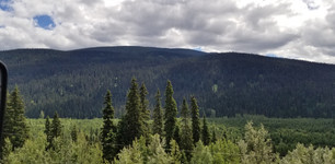
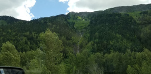
The route is beautiful and scenic. We are feeling good even after sitting for 3 hours on the road. The road begins to wind up the mountains.


We see after we start moving a portion of the road after the bridge was washed out. The scenery is beautiful. We are seeing moose, bear and elk signs, but of course we see none.
There are winding rivers along the route. We were told during our road stop the route is relativity flat except for Makenzie Pass. Lora learned from people she met during her walk to the accident site we need to stop in Chetwynd to see all the wood carvings. We see a baby bear hit by a car on the opposite side of the road. There is a tourist taking pictures of the bear.
We cross over Makenzie Pass and get stopped one again for construction signs. As we approach we see a crane digging on the side of the road. We are asked to move closer to the road truck on the side of us to allow road trucks to pass. We sit for 30 minutes while a dump truck dumps stones. Afterward they move down the road to fill the dump truck with dirt from the side of the road.


After we can start moving we see the road before the bridge was washed out and there was a 5-foot section of road filled with stone and dirt to allow us to cross.
The route afterward is easy, we move at a steady pace. We finally stop after getting down from the mountain.


We stop at Azouzetta Lake Lodge and Cabins in Fraser-Fort George G . It is a remote campground, gas station, lodge, and café. It is near Powder King Mountain Ski Resort. We are finally able to get some food. The location is beautiful. There is a lake and mountain sides with spots of snow on the sides. We ordered burgers and fries. We were amazed by the size of the meal for the cost. If you ever stop the quantity of food will surpass the price.


Once we finished our meal we moved on our route. We were in a no data zone so we could not find the specific route since I shut off my phone. Knowing we needed to only stay on one route is was not too important.


We pass through the town of Chetwynd. The town is known for its wood carving places throughout the city. Lora and I snap pictures of as many we could capture while driving. I stop at a 7-11 service station to top off the fuel. We are averaging 10.2 mpg over the last 17,800 miles.


We are within 1 hour of Dawson Creek and we can start to search campgrounds. After expecting to be here after 1:00 pm, we are now getting close to 4 pm.
We drive along rolling hills and rivers. The clouds in the sky are magical.


We come up to another accident on the road 12 minutes away from Dawson Creek. This time are stopped first in line. We turn off the truck and look outside. There is a dully Ford 3500 truck with a SUV connected to its rear. As we debate what happened a Lay’s delivery driver walks ups for behind. She and Lora notice the SUV is a police vehicle, thus now it gets interesting as to what happened. The driver mentioned there has been a rash of stolen cars.

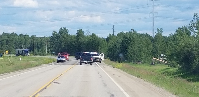


After a bit, a police office walks up to inform us we are going to be sitting for a while. He informs us the accident was an end of a police chase. He and another officer had thrown spike strips to stop the truck. An investigator was taking 3d scans of the scene. While waiting I was able to search campgrounds. I called Northern Lights RV Park and was able to book for one night. We asked for 2 or 3, but all she could give at this moment was one night. We are only 12 minutes away from Dawson Creek.
We were stopped for one hour. In all we have been stopped for nearly 4 ½ hours on the road for a 4-hour trip. A long day, but in all a good day with lots of scenery.
We reach Dawson Creek.

Northern Lights RV Park is on top of the hill outside of the main town. The host says we can stay for 3 days, but we decide on only two. We were first thinking of staying for Canada Day. The holiday is also called Victoria Day. They are expecting to have block parties and fireworks. The campground at first site looks crowded. We are placed in the back of the campground which is nice. We have a wide pull-thru site. After we get situated we walk around. The bathroom, showers, and laundry are in the same building as the office. There is a sign out front of the entrance asking to remove shoes in the mud room before entering the bathrooms, laundry and showers. The inside has beautiful tiles. The bathroom and showers are one of the best we have seen. Unfortunately, the shower costs $1.00 Canadian for 3 minutes. The $1.00 coin is called a loonie.


There is a caravan tour staying here at the campground. There are close to 25 campers in the caravan. Hearing some of the participants the cost for 2 people is $11,000 US. The tour is 60 days and covers the campgrounds fees, food, and attractions. There are two Ambassador Campers leading the group.
We finish the evening watching TV and catching up on the blog. We finish up the spaghetti from the other night and find the bed around 9:00 pm in full daylight.
The next day I sleep in till 7:00 am. The site comes with cable TV so I can catch up on new on Fox. I try to watch Fox & Friends if I get up early. If I want to watch the show I need to be up at 3:00 am to catch the first segment. Normally I get to see only the last 30 minutes, except on weekends when it goes for an extra hour.
Lora wakes up with her right side of her forehead and eye swollen. She was bit the other evening by mosquitoes on the forehead and maybe it is a reaction. She takes an Advil and puts Benadryl cream on her swelling.

Dawson Creek is in the dry and windy prairie land of the Peace River Country. The city has been called the "Capital of the Peace". It is also known as the "Mile 0 City", referring to its location at the southern end of the Alaska Highway.
We need to exchange some US currency for loonies to do laundry. Dawson Creek is only a few minutes from the campground. We leave the campground about noon. Down the street from the campground we see police lights. Another accident. We drive by slowly. There are at least three vehicles including a fifth-wheel. The fifth-wheel is jack knifed. The front end of the truck is smashed in. At the intersection there is two other vehicles smashed up. I turn around, so Lora can get her pictures. There a police, fire, and ambulances on scene.


We turn around just past the campground and pass the accident for the last time. We drive for a few minutes until we see a BC Liqueur Store. Time to buy more beer and wine. The box of Rose tastes good for Lora. The store is next to the visitor center. They were having a BBQ on the lawn promoting the library, museum, visitor center, and art gallery. I walked over to get a hamburger as Lora stays in the truck.
After eating my burger we drive about 50 feet to a parking spot on the street. We are within walking distance of Mile “0” Maker of the Alaskan Highway. The marker has been replaced multiple times. The original was taken down by a drunk driver years ago. The marker marks the exact spot the Army Corp of Engineers surveyor mapped the beginning of the Alaska Highway.
We take pictures of each other at the sign before walking back to the truck.


I walk over to the bank to exchange $40.00 US for Canadian currency and loonies.
I look at TripAdvisor for attractions nearby. Lora does not want to drive around looking for any wildlife. We will get to see them on the Alaska Highway. We find the museum named Alaska Highway House. It is on the corner next to the Mile “0” marker. The museum costs $5.00 per person. It is a very small museum with pictures and historical artifacts from the US Army Corps of Engineers when the road was build. They have a documentary on the building of the highway which was very informative.


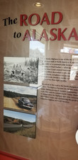


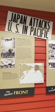


The Alaska Highway was conceived after the attack on Pearl Harbor. The US Army in Alaska told the President Roosevelt they could not defend Alaska if the Japan attacked. The US Army supplied Alaska by a series of airfield scattered through Canada. After a series of cargo plane crashes, the president and army decided to build a highway through Canada’s wilderness to supply the troops in Fairbanks, Alaska. The president ordered the Corp of Army Engineers to build the highway through uncharted land in 8 months. The length of the highway is 1520 miles from Dawson Creek, British Columbia to Fairbanks, Alaska. There were trains routes to Dawson Creek in existence so 10,000 troops (10 regiment) were round up and sent to Canada with no experience in building roads. 3 regiments were black soldiers. In 1942 the army segregated black soldier regiments from while regiments. It was also thought black soldiers cannot work in cold weather, so the 3 regiments were considered an experiment to see how the soldier would handle the weather and work with heavy equipment.
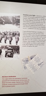
The soldiers were faced with extreme weather, snow, ice, mud, permafrost, and unchartered terrain. The documentary goes on for about an hour, but really gives a true account from the soldiers themselves of the hardship and challenges ahead of them.
While building the highway Japan captured two Islands in Alaska which we never knew happened. It was the first time the US was invaded in its history.
In eight months they completed the highway through Canada to Alaska. The meeting point where the black and white regiment’s bulldozers was captured in video and photos.
The black experiment changed the dynamics of the Army forever. The bridges were constructed using the logs cut down along the way. The bridges constructed by the black regiments lasted longer than any of the other bridges built in the first years. With the road open the Army was able to supply troops and equipment to Alaska and win back the two islands. The route also was used to supply planes to Russia fighting the Nazi’s on the Russian Front.
Here is a video on Building the Alaska Highway. We can’t wait to start our trek tomorrow on the Alaskan highway.
After visiting the Alaskan Highway House we drove to the Visitors Center. We were greeted by Lisa. She gave us important fliers and guides to help us along the highway. She highlighted specific items we needed to be aware of and where to visit. She was an amazing hostess for Dawson Creek Visitor Center. The visitor center also has a museum on either side as well. The cost is normally $5.00 per person to visit but was free today because of the BBQ earlier on in the day.


We head off to Walmart for groceries and at 30 amp to 15 amp adapter. After Walmart we top off the fuel tank.
On our way back to the camper we stop at the roundabout marking the beginning of the Alaskan Highway. The center of the roundabout is a metal statue of an Army Corp of Engineer Soldier point to Alaska. We take a few pictures of the marker and head back to the camper to do laundry.


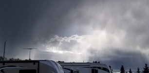
We spend the remainder of the evening hanging out in the campground. Lora loves how the sky is mixed with rain showers and sun at the same time.


I complete a load of laundry. We later talk with Phillip for almost an hour. Things are going well with them which is great to hear. They made an offer on a house, hopefully the seller will accept their offer. Tomorrow we begin our route on the Alaskan Highway.
I am up at 3:00 am or so and see the sunrise. It sunrise from here is amazing.


Today we venture onto the Alaska Highway. We are ready to be amazed...
If you want to follow us as we travel across America and Canada, please subscribe to our blog. The posting is our own opinions and experiences.


Comments