


Alaska – Valdez - Day 1 2 – Keystone Canyon Drive – State 18 of 49 on our RV Adventure
- Eric & Lora Benz

- Jul 8, 2018
- 10 min read
Updated: Jul 19, 2018
If you are a first-time reader, welcome to Lora and Erics RV Adventure Blog. You can read about us at http://www.LoraandEricsRVAdventure.com. We started in December 2017 with a goal to complete 49 states before heading home to North Carolina.


Two good nights in Tok, Alaska we are now ready to tackle the sights of Alaska. We are heading to Valdez, AK today. Valdez was a former Gold Rush town. A scam to lure prospectors off the Klondike Gold Rush trail led to the town of Valdez being developed here in 1898. Some steamship companies promoted the Valdez Glacier Trail as a better route for miners to reach the Klondike gold fields and discover new ones in the Copper River country of interior Alaska than that from Skagway. Many prospectors who were deceived because the glacier trail was twice as long and steep as reported. Many prospectors perished on the trail by contracting scurvy during the long winter. Valdez is also an ice-free port. The port is famous for fishing and oil. The Trans Alaskan oil pipeline ends at the Port of Valdez. It is also famous for the infamous oil spill from the Exxon Valdez in 1989.
The travel time from Tok RV Village & Cabins in Tok, AK to Bear Paw Camper Park Adult Park, Valdez, AK is 4 h 34 min 255 miles via BC-97 and AK-1 and AK-4.

Before we take off from Tok RV Village & Cabins we decide to wash the truck and RV at their wash station. I first stop at the office and pay for the service ($8.00 for the truck and $18.00 for the RV). There is only one RV at the wash station. When I walk back out and drive to the wash station there are now 2 RV’s at being washed and 2 RV’s in line. We are number 3. The draw back is the RV’s are given 45 minutes and the is no timer on the power washers. We nearly 1 ½ hours before our turn.
We hit the road at 11:11 am. The route is a straight shot down to Valdez. The weather is clear. Within a few minutes we begin to experience rough roads. It is sad when you have fresh painted lines right through bump, dips and gravel. The pot holes are nasty.

Flash back to earlier in the morning, Lora was reading her Facebook RV Tips page. She read a warning on removing the sink covers because the roads are so bad. I told her not be believe everything she reads. We drove the Alaska Highway without any issues and we were warned it was so terrible.
Within the first hour Lora spots a moose in a pond. Unfortunately, we are unable to stop.
Updating the tally we have the following: Black Bear: 14; Brown Bear: 3; Coyote: 3; Bison: ~15; Caribou: 2; Ram: 4; Elk: 4; Red Fox: 1; Bald Eagle: 3; Moose: 2
The roads are out of control, we can’t even enjoy the scenery because we are so focused on the ever-changing road conditions.


We begin to see snow patched mountains 2 hours into our drive. The roads are still outrageous. At 2:30 pm I pull off onto at turn out, so Lora can use the bathroom in the camper. She comes out a couple minutes later and tells me to look inside the camper. Walking in the sink covers are thrown off, the back-cabinet doors open, and dog food packets scattered all over the floor. She reminds me of our conversation earlier in the morning. We clean up what we can and place the sink covers onto the bed.


By 3:00 pm we are seeing mountains covered with snow. The scenery in becoming much more beautiful than our first visuals entering Alaska.


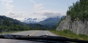


The road winds through the valley and hills. Several waterfalls are running down the hills from the snow on the mountains.
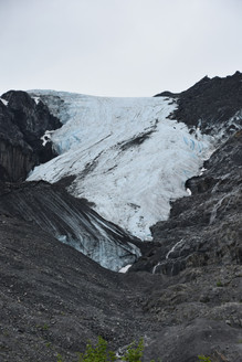
By 3:50 pm we see signs for Worthington Glacier. Worthington Glacier is a 5,774-acre valley glacier located adjacent to Thompson Pass.


We climb over Thompson Pass. Thompson Pass is a 2,805 foot-high gap in the Chugach Mountains northeast of Valdez, Alaska. It is the snowiest place in Alaska, recording 551.5 inches of snow per year on average.


As we drive down from Thompson pass we are amazed by the countless waterfalls and cascades flowing down the mountains. The beauty of Alaska reveals herself as we get closer to Valdez.


We stop at Bridal Veil Falls just off the road for a few pictures.

We drive by a cemetery where a funeral is going on. We later hear the funeral is for a 5 year-old boy killed while hiking on a trail be a falling boulder. The boy is the son of the police chief of Valdez.

We reach Valdez at 4:40 pm. We are normally one hour longer than Google Maps. I drive into Bayside RV Park thinking this is the park I need to check into before going to the Adult Park. The host tells me I need to go to Bear Paw Camper Park down street. She mentions the view at the Adult Park is really nice.


I drive a minute or two and I am at Bear Paw Camper Park. The campground is across from the Marina. I check in here for the Bear Paw Camper Adult Park.


The Adult Park does not have children. We drive out, make a right, then left, then first left with a dead-end sign. We pull up to the Bear Paw Camper Adult Park. The Adult Park is on the banks the harbor. One bank faces the Prince William Sound, the second bank runs along the marina entrance, the third section is on the hill side. Our site is 14 on the marina side. The showers, rest rooms, and laundry is in one building. The host lives in a house onsite. The home and facilities have beautiful hanging flower baskets. There are rabbits running all around.


We setup and are hanging out inside the camper, when I see a small brown bear come out from a path on the hill side walk past 3 picnic tables and climbs up the hill and out of site. I can get a few pictures before the bear disappears.


A little bit later Lora is talking with a camper staying in the far most site facing the harbor and hill. She mentions the bear was over at their campsite. Later I see the bear one more time before the end of the evening.
Updating the tally we have the following: Black Bear: 15; Brown Bear: 3; Coyote: 3; Bison: ~15; Caribou: 2; Ram: 4; Elk: 4; Red Fox: 1; Bald Eagle: 3; Moose: 2
The next day we are getting periods of rain. We decide to venture out regardless of the threat of rain. We can see the mountains poking through the clouds in between rain showers.


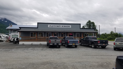
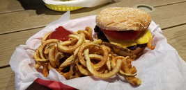
I fuel up in Valdez and head to Old Town Burgers for a bite to eat. We miss breakfast by 15 minutes, so we wait for the staff to switch over to Lunch. While waiting we decide to book a Glacier and Wildlife Cruise for tomorrow. I order a chicken sandwich and Lora orders a burger with fries. I did not realize my sandwich did not come with a side or I would have ordered fries. The chicken sandwich was satisfying. Lora was not impressed with her burger or fries.


After lunch we drive to the ‘Welcome to Valdez’ sign. Lora places one of her painted rocks on the base of the sign.


We begin to move toward Keystone Canyon capturing photos of as many waterfalls we can take without stopping on the road.

We stop at the cemetery we seen the day before. The cemetery has some historical significance. There are story boards explaining the unique cross which turn out to be Russian Orthodox.


We drive down to the cemetery plot of the 5 year old boy kill by a boulder when hiking. Lora places another of her painted rocks at the lap of a teddy bear.


From the cemetery we move a short distance to Old Town Valdez. The city was moved to its current location 4 miles down the road after it was devastated by the 1964 Good Friday Earthquake. There are plaques on some of the foundations marking what was once standing there. The whole town was wiped out by a tidal wave caused by the earthquake. Of the ~85 residents, 23 were killed in the tidal wave. We stopped at what once was the post office.


We are finally on the path to Keystone Canyon. Once again, we see taking pictures of waterfalls on the way.


Lowe River is raging down the valley. We stop at Horsetail Falls in Keystone Canyon.


I back track to check out a side road on the left side. The gravel road takes us to a bridge crossing over Lowe River on 4APL1 Road in hopes to find salmon running or a bear. In both cases we seen nothing. We get back onto Richardson Highway back on track to complete Keystone Canyon. We stop at Bridal Veil Falls for more pictures.


After Bridal Veil Falls we drive pass Rudleston Falls. We stop at Keystone Canyon Tunnel. The abandoned rail road tunnel is one of two along the Richardson Highway. Construction was started in the early 1900s as part of the Yukon-Valdez Railroad. After a gun battle with a competing railroad leaving one-person dead, construction on the Yukon-Valdez railroad was abandoned.


We decide to continue to Worthington Glacier Recreational Area. As we are heading up Thompson Pass we see a 5th wheel pulled over in a turnout with their hood up. We stop and ask if they need any assistance. The truck was overheating climbing up Thompson Pass. The engine light flashed to stop ASAP. Upon stopping the exhaust shot out blue smoke and a flame. The code reader was showing 3 codes that could not be cleared. I suggest disconnecting the battery to reset the computer. We tried it for a few minutes and it did not work. We offered to take someone anywhere we can get a signal on the cell phone to make a call. We take Scott’s father John with us to get some cell service. Scott, Betsy and John’s wife stay behind. We drive to a campground down the road, but find out it is a self-serve campground, so no help available or cell phone service. We then drive to Worthington Glacier because I remember seeing there is a gift shop on site. We get to the gift shop and the young guy running the store says there only a pay phone at the entrance and he cannot not suggest anyone to call in town. The attitude of the kid was sad, like he just didn’t care.
We drive back to the turn out. John is a able to get some cell service, but loses it when we get back to the turn out. There is another car. The two guys are familiar with diesel engines and say we needed more time to clear the computer with the battery cable off. They recommend 15 minutes. They also touch the red and black terminal connectors to speed up the drain. After 15 minutes they try to start, no luck.
We take John down the road to find a strong cell signal. We find a spot and pull off to the shoulder. While we are searching for the computer error codes, I decide to call Phillip to help search on his side. John then calls a friend he knows as well. Phillip calls back twice after he researches the codes and forums. The codes are DEF codes. If the truck sees a DEF error, the truck will not turn over. The codes need to be cleared to start the truck. Phillip read if a forum the battery needs to be unhooked for longer than 30 minutes. John also had a few suggestions from his contact.
We drove back to the turn out and offered what Phillip suggested. We dropped John off and Scott informed us a tow truck had been called by a passerby.
Lora and I headed back to Worthington Glacier Recreational Area to view the glacier. The blue that comes out of the glacier is amazing. We were about a ½ mile from the glacier from the viewing platform. We see people up near the glacier, so I decide to walk up for a closer look. Lora takes my keys and wallet and stays behind. The walk was not very long, but all up hill. I meet up with the group coming down the hill. They were from a glacier climbing tour. I walk up enough to see the waterfall below the glacier. There are petrified trees scattered all around which must have been buried by the glacier at one time.


I stay up on the mountain capturing as many pictures as possible.


After walking back down, Lora and I decide to drive back toward Valdez. We cross over Thompson Pass and pass Betsy, Scott, and his parents. There is a flatbed tow truck with them. We beep as we pass by.


As we get closer to Valdez I plug into Google Maps Valdez Glacier Lake. I had read there are chunks of ice in the lake even though you cannot see the glacier from the lake. The directions take us to Glacier Lake State Recreational Campground. We drive around the campground looking for any access to a lake. We find a stack a wood left behind from campers over the weekend. Lora and I load up the back of the pickup.
We eventually ask someone for directions to the lake. We are on the right road, but need to take the road to the end, follow the gravel road and it takes us to the lake. We drive down past a ‘No Trespassing Sign’ and to the lake. We take our pictures of the ice and leave shortly thereafter.


Getting back onto Richardson Highway heading to Valdez, I spot a black bear crossing the road.
Updating the tally we have the following: Black Bear: 15; Brown Bear: 4; Coyote: 3; Bison: ~15; Caribou: 2; Ram: 4; Elk: 4; Red Fox: 1; Bald Eagle: 3; Moose: 2
We make it back to the camper and call it an evening. The rain is becoming steadier. The next 2 days are expected to be 100% rain.
Tomorrow we are booked to take a Glacier and Wildlife Cruise with Stan Stephens Glacier & Wild Life Cruises. We are taking the Columbia Glacier Cruise. This 6-hour journey through Prince William Sound will feature a visit to the Columbia Glacier area where you have a chance to view history in the making as Columbia Glacier retreats into the Chugach Mountains. In addition to the amazing ice in Columbia Bay you will see wildlife along the way that calls the Sound home and have the opportunity to learn about the mining, oil shipping, earthquake, and fishing history of the area. They also serve a light meal on board.
I will create a separate blog of the cruise, so stay tuned...
If you want to follow us as we travel across America and Canada, please subscribe to our blog. The posting is our own opinions and experiences.


Comments